The Larapinta Trail winds 234 kilometers, plus various side
trips, from Alice Springs in the east, through the Western Macdonnell ranges in heart of the
outback, to Mt. Sonder in the west. This land is old. Like, really, really old. Mountains
once higher than the Himalaya have been worn over millennia to 1000- 1500 meters; meteor craters eroded by more than two kilometers.
Somehow, life has adapted to create such a brilliant
vibrancy in a harsh, arid, unforgiving place of drought and flood. From far
away the desert is glorious: an entrancing array of alien color stretching into
the distance. Up close, everything really just wants to kill you.
This is unlike what I usually publish: it’s basically a
transcript of the journal I kept on trail. It’s long and unpolished; in a sense
it’s what my brain looks like as my thoughts pour onto paper, still rough on
the edges. I’m posting as is because otherwise I simply would never have found
time to edit it properly...
_____
18.6.17: Alice
Springs Telegraph Station to Wallaby Gap, 13.5
km

On day 1 of the Larapinta, I consume 8.5 liters of water.
With ease.
It’s not that it’s hot– don’t get me wrong, even with 21º
days and freezing-ass cold nights, the sun is unbelievably intense. More to the
point, though, it’s just so obscenely dry
out here.
My trail partner and I set forward from the Alice Springs
Telegraph Station, following a rolling trail through silver shrubbery and
golden spinifex over angled red rock toward the beginning of the Western
MacDonnell Ranges.
Shade is sparse– the wispy shadows cast across rusty sand
where I choose to break would constitute almost full sun at home. We cross dry
creeks and dry rivers. We find old, squashed, rusted cars nestled amongst the
grass. Our company consists of the occasional lizard, dozens of flies, and more
ants than we can count.
Once we begin to climb onto ridges, I’m able to look down
onto the valley floor below me. The ranges rise in sheer, red, uplifting
features, facing each other in a yawning, jagged gap across a broad valley. The
valley floor itself shines a brilliant gold in the afternoon light, thousands
upon thousands of grass-crowned dunes extending out of sight in a mesmerizing
ocean of gold, separated by the deep flowing green of bush trees.
_____
19.6.17: Wallaby
Gap to Simpson’s Gap, 11.1 km
Today fast becomes a study of the beauty to be fond in the
minute, in a place where fire and wind are synonymous with life and
regeneration.
Our trail wanders through a sea of gentle dunes beneath
striated red cliffs. The bush around me brims with life to be found in arid
landscapes: clusters of firey red blossoms extend in slender trumpets from
wispy shrubs. Tiny black ants swarm dangling clusters of light waxy green
berries. Dead, fire-blackened bushes cling to plump seed pods burst open by
past flame. Brilliant white gum trees rise from dry rivers and waterholes, shimmering
bark streaked in fine orange where sap and rain have trailed dust. Bloodwood’s
bark shines in an orange and white and burnt black mosaic against ever-present
golden grass. Tall, vibrant, reedy grasses crowd a compact water hole. Nearby
zebra finches flutter amongst the trees as though they were butterflies.

A constant breeze sends waves through the bush and cuts the
day’s heat. Chunky orange and white blocks line our trail; evidence of volcanic
intrusion in the yawning maw of a valley in which I find myself presently
located. The land changes around us as we walk; dunes around the surrounding
ranges shift from a golden green to a deep ochre as they turn into the
distance. As for waterholes and drainages? They’re bone dry. Mineral lines mark
water levels of days past; months or years, or even days, of wetter weather.
Simpson’s Gap, when we arrive, swoops down to greet us in
spectacular fashion. Tumbles of shattered boulders piled high against the
canyon’s walls hide rock wallabies as we approach. The imposing, delicately
striated cliffs we’ve passed beneath during the day’s walk fold and tumble to
line a sheer, steep canyon with square, jagged edges piled upon the thousand.
Deep in the bottom, above a broad, sandy gray bed dotted with lush monster
white and green gum trees, lies a clear, serpentine pool. Water ripples beneath
a cool afternoon breeze as the water curls around the rock’s shadowed base.
_____
20.6.17: Simpson’s
Gap to Mulga Camp, 16.7 km
Whoever plotted this trail was a goddam genius. For 16
kilometers today we weave through rocky red dunes amongst grass half my height.
Sometimes the grass is so thick I can’t see where the trail leads until I’m
within a meter of a turn. Looking forward or back across the land, our path
disappears entirely… however, somehow throughout the entire day, our trail
never hits more of a slope than a gentle rise or fall.

The ranges spreading away from us as we leave Simpson’s Gap
have shifted to a deep burnt red devoid of vegetation, stretching behind our
golden dunes to the cloudless horizon in line upon line of red, green, gold,
silver and black. We cross broad, gray sandy riverbeds devoid of water but full
of green river red gums, thriving as thin roots reach deep to gather moisture.
We traverse miles of dunes come through recent burns, vibrant green shoots
emerging from earth darkened by ash. And we duck into Bond Gap, a water hole
where deep water glowing icy golden-green meets head-high reeds under sheer
firey rock walls and a clear blue sky and a fresh, brisk breeze chills the air.
_____
21.6.07: Mulga
Camp to Jay Creek, 10.8 km

“How’s the weather?”
“The same. Bloody hot and dry and not a cloud in sight.”
I pitched my tent last night on a circular sandy patch
ringed time and time again by dingo tracks. I double-bagged my food and stashed
my boots inside a pack fastened tight. Then I prayed– just a little bit– to the
gods of bushwalk karma as I went to sleep.
I wake to safe food and boots.
Our walk today is short but sweet: we swing around the back
of Mt. Lloyd on a mellow trail, the mountain’s rolling, rocky peaks building
upon each other to parallel our journey from across a gentle valley. We pass
Spring Gap soon after we leave camp. The still, round waterhole framed by
arching eucalypts hosts a school of small, dark, darting grounder fish. The
fish, currently zipping about their happy place, will literally pull themselves
through tunnels in the ground on their fins once the water dries. Just up a
nearby slope, bloated gums squat over a small, sludgy trickle of a natural
spring from which the waterhole is fed. Drab songbirds with long, vibrant blue
tails flash amongst the shrubbery.
The water is frigid.
Like, snow melt frigid.
Every water hole is a blessing, though: an oasis of peace
and icy water in the midst of a blistering desert.
Fish Hole, a kilometer and a bit of a sandy slog beyond this
evening’s camp, brims with life. Beneath mountain slopes banded black by fire
in an intricate play of rock and ash and light and sparse surviving vegetation,
boulders marbled black and white and purple line the dry river bed. Cycads–
ancestors of palms and ferns– line our the way in. Orange and white granite
lines a long, narrow pool. Black and white wagtails strut along the water’s
sandy shores. Broad, smooth, flat rocks stained black extend into the water.
Gum trees line the banks, and olive-colored songbirds flit amongst young,
slender saplings.
In short, after an afternoon cat nap and dipping my feet
into an icy pool, I have reason to believe I’m human again.
_____
22.6.17: Jay
Creek to Stanley Chasm, 13.8 km

Still Alive. Three soul-crushing, rock-bashing passes in the
space of ten kilometers.
Seriously, hiking through sand sucks.
We follow a broad, dry riverbed for over a kilometer before
venturing upward past Fish Hole into a rugged wonderland, and the territory of
the devil. Spinifex looks cute from far away, like little green fluffy pompoms
scattered in evenly-spaced blankets across the Chewing Range’s imposing orange
slopes. Up close, it’s the devil’s spawn. The grass consists of an airy ball of
thousands of long, pale green needle-like spines, growing outward from a dead
black center.
They rake across your legs.
They pierce your sleeping pad.
We pack our backpacks so they don’t pierce through the
exterior and into our stuffsacks, into our sleeping bags.
The stuff is everywhere.
Spinifex thrives on the slopes here, which is incredible
considering it’s one of the only things that even survives. Word has it, if you took a box of cereal and took out the
cereal and the coupons and the plastic bag, and ate only the cardboard, you’d
still gain more nutrients than if you ate the spinifex grass growing on the
plains out here.
That being said, the territory is breathtaking. We‘ve left
Jay Creek behind, climbing into the Chewing Range’s swooping orange expanses.
We follow rocky drainage after boulder-filled ravine and scramble through
narrow notches above sheer orange bowls. We pass vibrant fuscia flowers and
deep orange desert pea blossoms. We stop to refresh (read: regain a sense of
life) in breezy nooks next to trickling springs where zebra finches flock.

This is by far the most rugged territory through which we’ve
passed. Orange bowls rise to undulating ridges and give way to jagged,
golden spines, flowing brokenly through the rock as they tower overhead,
marking the range’s path and giving a cross-section to hundreds of millions of
years of history.
Toward the end of the day our trail descends thousands of
steps into more yawning, jagged, broken rock, deep orange and red glowing as it
rises in sheer, halfhazard chasms overhead.
Stanley Chasm is a sacred place. The second permanent water
source we’ve passed so far, its water comes from groundwater and runoff
collected and retained through the less-porous rock of a myriad of drainages
comprising a monster watershed.

The chasm itself, above the flowing creek, is currently dry:
vertical walls frame a slot canyon left behind by eroded dolomite where rare
blossoms cling to the rock high overhead, and midday sun streams down to form a
fleeting tunnel of light. The rock around me– sandstone become quartzite– dates
back 2.2 billion years… I walk amongst ancient history. Some of the endemic
cycads surrounding me in the ravine are as old as 1,000 years.
_____
23.6.17: Rest
Day, 1.0 km
Stanley Chasm.
Boot Repair.
Shower.
Laundry.
Food Resupply.
Falcons murdering pigeons.
Trashy romance novels.
100% unapologetic.
_____
24.6.17: Stanley
Chasm to Brinkley Bluff, 10.5 km
Today is a long, mellow ascent up drainages and across
ridgelines into heaven. Hauling 5.5 day’s food and seven liters of water
seriously sucks. The scenery makes up for it all.
We begin hiking at 6:30 am, stars overhead, making it all
the way up and out of the snaking drainage that forms our first five kilometers
before the sun hits. Wind accompanies us in a godsend of a breeze as we follow
a dragon’s spine of uplifted knolls and saddles, picking our way over crumbled
quartzite as the Chewing Range shrinks below us. When we arrive atop Brinkley
Bluff, mountains fan out in an orange and green spider web below us.
The sun is intense up here. Intense and bright and shines
from a sky so neon blue I didn’t even know that color existed in the natural
world. It’s bright enough that my sunglasses want sunglasses.
The air stills around midday, as I relax on an improvised
rocky seat in the shadow of the bluff’s monster cairn away from the spinifex.
Even up here, swallows ride thermals through the sky above me on stout wings
and stubby tails. Firetails shuffle through nearby shrubbery and flit over
rocks, as well.
I have the whole of central Australia spread before me. For
the famed Outback desert, it’s so vibrant:
streaks and bands and ridges of orange and white give way to green and gold and
red, give way to blue and purple and maroon, give way to a deep indigo and
purple as ranges rise in silhouettes beneath wispy white clouds on the horizon.
In the evening we watch the sun set as shadows lengthen
behind us, ridges far below us glowing in the day’s last light as mountains’
shadows rise into the sky.
_____
25.6.17: Brinkley
Bluff to Section 4/5 Jucntion; 7.4 km

The desert wakes in deep, muted pastels far below me as dawn
approaches. The sun rises under blazing clouds as I make coffee on the summit,
washing the Chewing Range in a honey crimson glow.
The day is mellow: we descend into a broad, gentle valley,
passing back into tall, golden grass and deep red earth packed to fine dust,
bringing to mind the earth around Uluru.
Although balmy nights are appreciated, days have become
incredibly hot: by 1:30 pm, the sun glares down with unfathomable intensity.
Especially for the middle of winter. Not so unlike snow, the ground itself
reflects the sun into our faces. And so we start hiking early, usually between
6:30 and 7:00, most often arriving into camp before noon. We catnap. I journal.
I do laundry and look over maps. I rehydrate, make dinner, and go to sleep soon
after dark… and then we do it again. It’s an easy rhythm out here, without
service, without “city things” to worry about.
Except paying bills from mountaintops.
Later in the afternoon a somewhat haggard gentleman stumbles
into camp. As I patch him up from an unfortunate tumble– somehow he managed to
land in a pile of spinifex next to an ant hill– we discover we have friends in
common back home, as he’s filmed documentaries on the PCT. Funny how people can
collide across the world…
_____
26.6.17: Section
4/5 Junction to Hugh Gorge, 13.5 km
Spencer Gorge: 1; Gavi’s leg: 0.
Today was spectacular.
It rained last night, fresh air sweeping in with a light tap
of water overhead. By morning, it was dry.

We broke camp under cool, cloudy skies, scrambling and
boulder-hopping Spencer Gorge’s 2-kilometer length through brilliant– albeit
thorny– wildflowers clustered in yellows and fuscias and orange, saying hello
to little slot canyons as we passed them to the side. As we scrambled out of
the gorge a pair of feral cats began fighting in the cliffs above us, screams
rebounding between the canyon’s walls.
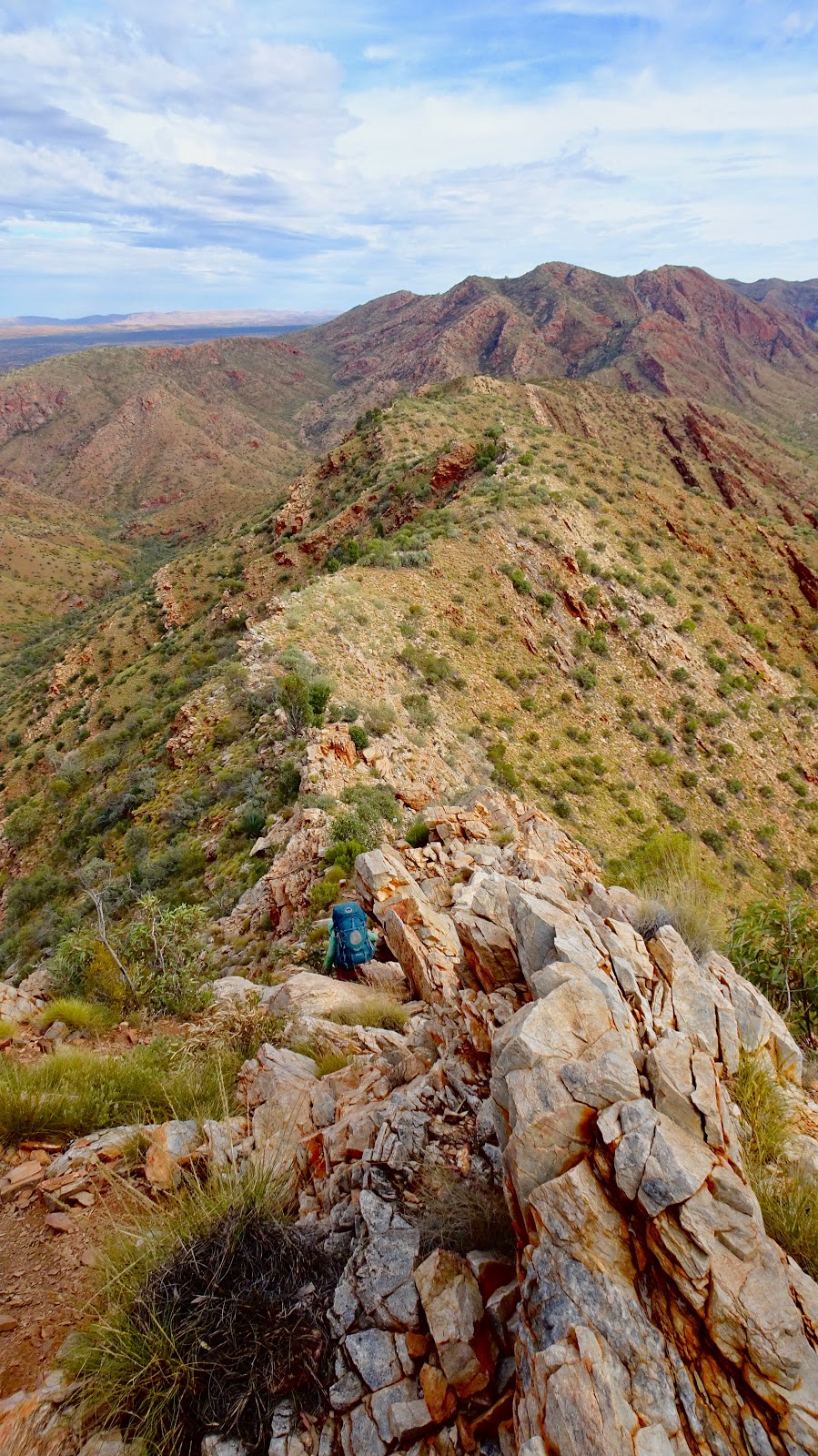
We climbed steadily to the top of Razorback Ridge, from
which we could look down on the rest of today’s path: a vertigo-inducing
traverse down a sheer spine, a scramble down a steep scree-covered spur, a
gently sweeping valley along Fringe Lily Creek, and another short climb before
dropping into Hugh Gorge’s cradle beneath sheer, monolithic orange walls.
Wind rose as we traversed Razorback Ridge, skirting boulders
along the spine’s sheer edge. Ghost gums, slender trunks shining smooth
silver-white beneath deep green foliage, greeted us on spurs and knolls. A tiny
bearded dragon darted amongst the rocks and spinifex as we dropped into Hugh
Gorge.

Later in the afternoon we detoured into Hugh Gorge’s upper
recesses. We passed scattered, dwindling pools filled with hundreds of fish,
following deep red walls as they narrowed to a sheer canyon beneath a dry
waterfall. We swam (read: splashed freezing water on ourselves) and retrieved
water for the night from a narrow pool held between walls over 100 meters high,
water’s reflection so deep and clear I could truly believe I looked down
through an abyss to another world’s sky.
Birds so green as to be mistaken for eucalypt leaves when
they alight amongst the boughs frequented the trees around my campsite in the
deep sandy riverbed. Crows called mournfully and wagtails hopped along the
ground and downed logs…
_____
27.6.17: Hugh
Gorge Junction to Rocky Gully, 19.0 km
We rise early again today, packing under stars by the
cliff’s watch before picking our way down Hugh Gorge as the sky brightens. The
gorge brims with life: reeds and shrubs and a rainbow of sludge crowd water
holes all along our route. Debris piles high against trees grown leaning
downstream in evidence of monsoon floods. Waterholes pool in the riverbed and
against the canyon’s walls, occasionally requiring a finicky traverse to
navigate surrounding rock without getting wet.
The rest of our day’s walk proves long but relatively
simple: under cover of lucky cloud and a constant breeze we make our way out
into the Alice Plains, beginning a two-day crossing between ranges. Our path
leaves behind spinifex slopes for rocky dunes and golden grass once again,
winding amongst hilly dunes to outlooks. These dunes dwarf those amongst which
we walked during our first three days on trail, rising in gentle hills far
above our heads in a dizzying, disorienting array of gold and bronze. At times,
dunes rise so far over our heads we appear to be nestled in gentle valleys,
unable to see anything but sky. Other times, we look out to the west to where
the ranges extend so far, their rugged, stark-shadowed peaks appear to meet in
the distance. Looking back, we can pick out the exact path our journey has taken
us over the last several days…
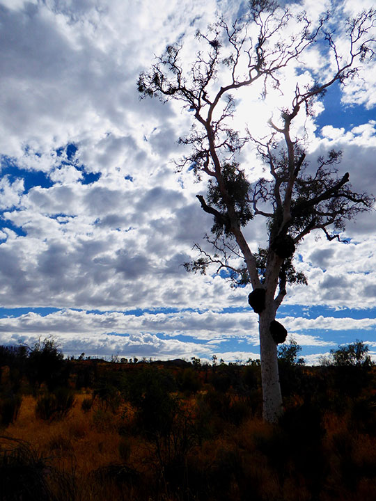
We drop into a low flat to eat lunch under watch of an
ancient ghost gum, gnarled with black burls larger than my torso, branches
broken and mostly dead, kept alive by copious epicormic growth.
Clouds move in overhead after we make camp, spitting on us
in short bursts through the evening.
_____
28.6.17: Rocky
Gully to Ellery Creek, 16.3 km

We woke today to a low, deep gray blanket of cloud nipping
at surrounding peaks. We walked an easy 16 kilometers through mist so fine it
almost didn’t exist, in a chill just cool enough to strip excess heat as we
finished crossing the plains on our passing to the Heavitree Range, scaring up
little quail-like spinifex pigeons along the way.
We dropped into Ellery Creek under low clouds, and shortly
thereafter the mist turned to a cold, persistent drizzle. All day and into the
night.

Ellery Creek, however, is a gem: a massive waterhole beneath
a gap in the ranges extends to a broad, round pool surrounded by soft sandy
banks and gum trees. Even in dismal weather the waterhole brims with life: a
small grebe shuffles through the water’s edge. A heron of some sort twists and
contorts itself through the air overhead as it plays in the wind. Finches teem
in the eucalypts around me. Dead fish rim the water: a natural return of
nutrients due stress associated with winter water temperatures and a parasitic
organism of some sort.
In any case, given the fish and the wet weather– which has
turned to miserable, wet, persistent, bone-penetrating cold– I turn down the
opportunity to swim… the shower will have to wait.
_____
29.06.17: Ellery
Creek to Serpentine Gorge, 12.9 km

Yesterday evening, dingos began howling as I turned in for
the night. A group of younger girls who haven’t yet begun to hike began
freaking out, so a couple of guys in camp decided to take out the piss by
howling along with the dingos.
Hilarity ensued, and I woke to a (live) walking stick on my
backpack.
We set out for a cruisey day under lifting cloud and solid
wind, twisting west along the range’s base. These mountains are so strikingly
verdant; so much more blazing in deep, dense green than the Chewing Range from
which we’ve come. Even just a day after rain, the desert bursts with new life.
Desert roses blossom in broad, delicate pink petals, and trumpet-style violet
flowers have begun opening in clusters amongst other shrubs.
Our trail winds through drainages where spinifex taller than
myself wars for territory with a myriad of other shrubs. We traverse low ridges
composed of new, sharper rock– deep purple and red and black, twisted as if
fresh out of the earth, occasionally glowing a deep indigo. The land is
different here: more hilly, more texture, more variation in vegetation and
rock. At times the rock under our feet swirls a light, pocketed gray purple. From
Trig Point, half way through our day, we look back to where ranges run red and
green behind us, breaking clouds adding an extra dimension in shadowed
landscape…
_____
30.6.17: Rest
Day, 4.0 km

I feel like an incredibly selfish person sometimes: I have
to be one of the luckiest people I know. I’ve been given, and I’ve made for
myself– the opportunity to do some incredible things. But sometimes, an
interaction– or a moment– makes me wish for nothing more than to be at home
amongst familiar people of common backgound… even if, for all intents and
purposes, I’m on the home stretch of this incredible, unimaginable journey.
Today was one of those days.
Serpentine Gorge snakes and bends from north to south through
the Heavitree Range, guarded on the southern side by a small, sheer-walled
waterhole. We– myself and a fellow outdoor eddie I’ve met on the trail– traverse
slopey, polished, spooky rock above shallow, frigid water to gain the inside of
the gorge. For the sake of dry shoes on tomorrow’s walk my boots have stayed
behind, so I rockhop barefoot a few hundred meters under the gorge’s cracked
walls as they buckle and fold above me before finding a broad, half-shaded boulder
on which to sit under a twisted ghost gum, watching birds emerge as wind teases
the canyon.
Later in the evening as the sun sets, I climb to the gorge’s
lookout and find myself utterly alone, watching shadows extend to cloak a more
distant slot canyon guarded by bare red walls, that my earlier lack of shoes
prevented me from reaching. A breeze teases the air while behind me, rolling
ranges darken as shadows lengthen under the sun’s glow.
Three days to Ormiston.
Bring it on.
_____
1.7.17: Serpentine
Gorge to Serpentine Chalet Dam, 15.3 km
Today we venture for the first time into the Heavitree Range’s
high ridges, greeted by howling wind as we traversed broad, rocky spines. Serpentine
Gorge shrinks steadily as I cruise forward, following ridges higher and higher.
New plants grace the range: compact banksia shrubs bend in the breeze, boasting
hot pink blossoms, and scattered stout alpine desert pines grow proud and
straight on the range’s highest points. Occasionally, when all other vegetation
disappears, low, miniature, delicate plants root steadfastly amongst small
stones.

We swing off trail to lunch at Count’s Point, where five
major spines comprising at least three ranges extend below us into the distance:
various shades of reds and grays and golds in a sea of verdant green, fading to
blue haze under clear azure skies. Stark shadows cast by the late morning sun cut
every deep gorge and valley, and darken the south side of every peak and crease
running parallel to my rocky lookout. Far in the distance to the east I spot
Mt. Sonder for the first time, cloaked in deep blue haze. On the horizon to the
south, Gosse Bluff– a colossal crater rising in evidence of a meteor’s impact
130 million years ago– presents a broad, flat outline.
As we descend from Count’s Point we enter new vegetation
zones, where chartreuse shrubbery has evolved thousands upon thousands of
leaves into thousands upon thousands of inch-long, razor-sharp thorns. The
stuff is so thick it changes the color of the slopes, resulting in horizontal
bands glowing green yellow high on the ranges above the south side’s eucalypt
and tea tree forests.
_____
2.7.17: Serpentine
Chalet Dam to Hermit’s Hideaway, 17
km
What an epic day.
17 kilometers and a water carry. A silent slip of a pass. A
big, broad, happy open valley. Waterfalls run dry. An utter monstrosity of a
climb up a steep, scree-covered spur. And a ridgetop campsite to shame the rest
of the world.
We set out early, as per usual on bigger days. Our path
wound along the Heavitree Range’s densely vegetated south base before turning
into Inarlanga Pass– a natural boundary marking change of domain for the land’s
traditional custodians. A single bird’s clear melody pierced the pass’s silence
as we navigated jumbled boulders in morning shadow, passing beneath rock
twisted as though to cradle the trees it sheltered.
We emerged under jagged ridges to a long, open valley
extending in front of us in gentle waves. Between kilometers filled with thorns
and spines as Satan’s Spawn #1 (read: spinifex) warred for territory against
Satan’s Spawn #2 (read: thorny yellow thing; name unknown), hidden shaded pockets held waxy neon pink pod-like flowers. Occasionally we
found a stretch of low, dense shrubs alight in thousands of tiny yellow cotton ball
blossoms.
We turned once again into a narrow gorge, passing deep
orange and black walls and sandy holes devoid of rushing water present during the
monsoon. We navigated another rocky river bed, and then we began to climb. In
less than a mile of scrambling and traversing crumbled, sliding rock we gained
almost 1,000 ft, topping out to an utterly glorious view of the ranges from
whence we’d come. Across from me lay Mt. Giles, crowning the eastern end of the
Chewing Range, in which we’d spent our first week on trail. To my left, a
series of ridges stretched forward, bowing before Mt. Sonder. Behind me, the land
of the Northern Territory stretched to the horizon far below in endless
parallel creases and ripples and golds: a topographic relief in full scale,
sharpened by afternoon sun and shadow. Mt. Zeil, Australia’s highest peak west
of the Alps, rose behind Mt. Sonder in the distance, and far in the horizon
that monster meteor crater rose as a broad, jagged silhouette.
We camped a kilometer down the ridge, nestled in a cluster
of trees known as the Hermit’s Hideaway, tucked away from ever-present wind. I
watched shadows lengthen throughout the afternoon and in the evening I made
dinner on a small rocky outcrop as the sun sank. The sun set directly behind
Mt. Sonder, throwing up a blazing halo around the mountain and turning the land
from a shining green and blue to a wash of violet and orange and gold, and the
land faded to a deep black silhouetted by crimson and firey orange as I turned
out my light.
_____
3.7.17: Hermit’s
Hideaway to Ormiston Gorge; 11.6 km

Last night the half moon was so bright overhead I could
clearly see Mt. Sonder in the distance. I woke more than once thinking I’d
slept past my alarm into dawn. Our copse of small trees protected us from the
night’s wind until it died down, and after the moon set I slept like a rock.
The sun rose opposite Mt. Sonder. sending amber rays through
notches in the Chewing Range behind Mt. Giles and casting the mountain aglow in
a deep, intense ruby over nearby darkened ridges, as I made the morning’s
coffee.

We descended the ridge into cruisey walking through
spinifex-blanketed dunes, passing the occasional shallow, shaded drainage and crossing
beneath jagged, narrow, steep gorges tumbling from the ridges above. Every so
often the earth beneath our feet turned to crumbled dark, twisted, iridescent rock,
and a new plant reared its delicate head solo from the barren land: a low,
delicate, thick yet reedy groundcover brimming with stalk upon stalk of violet
blossoms so thick as to change the color of the land when viewed from a lower
angle.
We arrived in the early afternoon to Ormiston Gorge, a deep open red gorge with broad sandy beaches, a monster of a swimming hole, and quite possibly the best chicken burger of my life. Also a food drop. Also showers.
Hallelujah.
_____
4.7.17 Ormiston Gorge to Finke River; 9.0 km
Today was supposed to be a cruisey 9 km; the easiest of the
lot. Today was an utter shitshow.
Three hours of exposed spinifex dunes, with no shade to be
had. The heat absolutely killed. No
wind. I did something to my foot yesterday, and to say it’s not keen on the
weight of a full pack would be a gross understatement. Between the heat and the
wind and the exposure, I felt by far weaker today than any other day on track:
aside from that monstrosity of a climb out of Waterfall Gorge two days ago,
today is the only time I’ve honestly thought I was going to hurl every time I
began to ascend a gentle incline.
Also: my hiking partner, a male in his late 40s, seems to be
of the firm belief that I’m unable to take care of myself on trail. He has the
last word in every conversation, contradicts every comment I make, and fails to
acknowledge when he’s wrong (which happens to be most of the time). The way he
worries over me is suffocating– and frankly a bit infuriating– considering my
profession consists of looking after myself and 15-odd others for extended periods
in the bush.
Also: I legitimately lost a pair of socks today.
Today was saved by the little things: I wandered up to an
overlook over Ormiston Gorge this morning, standing below a large, elegant
ghost gum high on an outcrop above the canyon’s main waterhole, whose roots
have extended seventy meters down into the rock to tap the water trapped within.
New blossoms lined our path out of Ormiston, bright pink
trumpets and yellow petals and some kind of large daisy greeting us in the late
morning.
A lone bloodwood atop a hill in the middle of our walk today
offered some shade as we gazed over the valley toward Glen Helen, situated in a
small gap beneath striped maroon ridges, and back across the Heavitree Range.
We crossed Ormiston Creek late in our walk. The broad, bare,
sandy bed was strewn with wispy trees and monster red gums upon which masses of
dead matter piled and wrapped and cocooned after flood. On second glance we
discovered a broad, clear billabong covering the river’s girth to our right,
lined by tall greeny-gold reeds and host to a tiny sand piper making its way
through bordering damp sludge.
The Finke River, too, greeted us with a beautiful billabong
lined with leaves under tall trees. Late in the afternoon, after the sun
dropped far enough to cease baking the land, I splashed in the cool water next
to tiny, striped fish as my laundry dried in camp.
T-3 days.
I can do this.
Tomorrow will be better.
_____
5.7.17: Finke
River to Rocky Bar Gap, 14.3 km
This morning was filled with birdsong as we cruised the
lowlands south of the Heavitree Range, crossing dry riverbeds and skirting
lush, reedy billabongs. Herons warred for strategic branches, peregrine falcons
hunted in dawn light over the dunes, and new violet blossoms opened from fuzzy
stalks.
We climbed a ridge to the last of many “Hilltop Lookouts,”
emerging straight across from Mt. Sonder’s sheer, looming faces and jagged
skyline. I looked down into the dunes from whence we came, where a deep,
twisting green band marked the Finke River and its tributaries: the lifeblood
of this dry, open, arid, desolate land.
One big hill to go.
_____
6.7.17: Rocky
Bar Gap to Redbank Gorge; 14.4 km

Easy morning walk into Redbank Gorge, path lined with
rosebush after desert rosebush, welcoming and cheery even in the early shade.
Also: over a kilometer of spinifex grown well over my head.
The gorge is mindblowing. The notch’s jagged walls careen
into each other, misfit jigsaw puzzle pieces separated by the space of a three
meters or so over a passage of dark, frigid water. Nearer to camp I find
several clear, less fishy-smelling, waist-deep pools.

While I bathe, our first mammalian wildlife of the entire
trip makes an appearance (
finally!)
in the form of rock wallabies. The tiny, brown-striped marsupials wander down
from the cliffs as the sun fades, making their way along the walls above me. They’re
so well camouflaged that when they stop moving, they become impossible to spot,
one amongst the rocks, long dark tails wrapped neatly around dainty gray and
brown bodies.
Mount Sonder tomorrow.
_____
07.7.17: Redbank
Gorge-Mt. Sonder return, 15.6 km

We climb Mt. Sonder in the frigid, early morning against a
deafening headwind, topping out as a deep pre-sunrise crimson glow fades and
the sun crowns the northeast horizon.
I celebrate by downing a double-shot of whiskey given to me
by a legend of a man back at Ellery Creek, carried in a battered Nalgene bottle
and sealed with strapping tape. Also a bar of chocolate. Also three cups of hot
tea and arrowroot cookies carried up by a guide who’d rather not carry them
back down the mountain.
When I return to Alice in the evening, I ceremonially bin my
battered boots and eat a beauty of a chicken veg pizza, with all the good stuff.
20 days.
250 km.
No snakes.
No punctured sleeping pads.
No sunburns.
No blisters.
Nailed it.
 After 22 hours on the bus, five hours at the airport and a
midnight flight, I land my butt in tourist Bali at 2:30 am. Ubud, to be exact,
a little further inland than boom-boom surf and party central.
After 22 hours on the bus, five hours at the airport and a
midnight flight, I land my butt in tourist Bali at 2:30 am. Ubud, to be exact,
a little further inland than boom-boom surf and party central. Despite not really feeling like I’ve arrived in Indonesia
(okay, I can’t read half the street signs and motorbikes swarm everywhere), somehow I’m not all that bummed about being here as a base to
figure out my next month. There are cheap massages everywhere I look. There’s
some half-decent food and really decent prices (read: $2 scoops of charcoal-bamboo or dragonfruit-cinnamon gelato. $1.50
for the best cappuccino of my life, made from beans eaten and pooped out by
wild tree cats). The people-watching is spectacular (did I mention the fancy French woman in designer clothes who gave me a death glare because I couldn't hold it together when I noticed her toddler licking the giant black dick-shaped bottle opener she was bargaining for in the market?) Also, I may or may not have watched Game of Thrones on the big screen at “The world’s first organic vegan cinema.”
Despite not really feeling like I’ve arrived in Indonesia
(okay, I can’t read half the street signs and motorbikes swarm everywhere), somehow I’m not all that bummed about being here as a base to
figure out my next month. There are cheap massages everywhere I look. There’s
some half-decent food and really decent prices (read: $2 scoops of charcoal-bamboo or dragonfruit-cinnamon gelato. $1.50
for the best cappuccino of my life, made from beans eaten and pooped out by
wild tree cats). The people-watching is spectacular (did I mention the fancy French woman in designer clothes who gave me a death glare because I couldn't hold it together when I noticed her toddler licking the giant black dick-shaped bottle opener she was bargaining for in the market?) Also, I may or may not have watched Game of Thrones on the big screen at “The world’s first organic vegan cinema.” On my third night, one of the town’s temples puts on a
three-part ballet. Dozens of men perform music without instruments in
chattering concert as dancers bring legends to life.
On my third night, one of the town’s temples puts on a
three-part ballet. Dozens of men perform music without instruments in
chattering concert as dancers bring legends to life.